Autonomous Robots Lab
  • Home
  • News
  • Research
    • Autonomous Navigation and Exploration
    • Fixed-Wing UAVs
    • Agile and Physical Interaction Control
    • Localization and 3D Reconstruction
    • Subterranean Robotics
    • Collision-tolerant Aerial Robots
    • Marine Robotics
    • Intelligent Mobility >
      • Student Projects
      • Electric Bus Datasets
    • Robotics for Nuclear Sites
    • Degerminator
    • Autonomous Robots Arena
    • Code
    • Media
    • Research Presentations
    • Projects
  • Publications
  • Group
    • People
    • Research Collaborators
    • Positions
  • Education
    • Introduction to Aerial Robotics >
      • Online Textbook >
        • Modeling >
          • Frame Rotations and Representations
          • Multirotor Dynamics
        • State Estimation >
          • Inertial Sensors
          • Batch Discrete-Time Estimation
          • The Kalman Filter
        • Flight Control >
          • PID Control
          • LQR Control
          • Linear Model Predictive Control
        • Motion Planning >
          • Holonomic Vehicle BVS
          • Dubins Airplane
          • Collision-free Navigation
          • Structural Inspection Path Planning
        • Simulation Tools >
          • Simulations with SimPy
          • MATLAB & Simulink
          • RotorS Simulator >
            • RotorS Simulator Video Examples
      • Lecture Slides
      • Literature and Links
      • RotorS Simulator
      • Student Projects
      • Homework Assignments
      • Independent Study
      • Video Explanations
      • Syllabus
      • Grade Statistics
    • Autonomous Mobile Robot Design >
      • Lecture Slides
      • Semester Projects
      • Code Repository
      • Literature and Links
      • RotorS Simulator
      • Video Explanations
      • Resources for Semester Projects
      • Syllabus
    • Robotics for DDD Applications
    • CS302 - Data Structures
    • Student Projects >
      • Robot Competitions
      • Undergraduate Researchers Needed
      • ConstructionBots - Student Projects
    • EiT TTK4854 - Robotic Ocean Waste Removal
    • Aerial Robotic Autonomy >
      • Breadth Topics
      • Deep-dive Topics
      • Literature
    • Robotics Seminars
    • Robotics Days
    • Outreach >
      • Drones Demystified! >
        • Lecture Slides
        • Code Repository
        • Video Explanations
        • RotorS Simulator
        • Online Textbook
      • Autonomous Robots Camp >
        • RotorS Simulator
      • Outreach Student Projects
    • BadgerWorks >
      • General Study Links
      • Learn ROS
      • SubT-Edu
  • Resources
    • Autonomous Robots Arena
    • Robot Development Space
  • Contact
Autonomous Teamed Exploration Path Planning
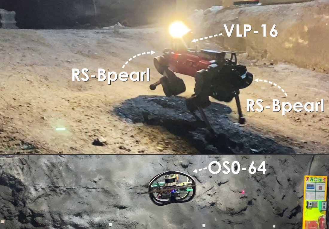
Abstract: This paper presents a novel strategy for autonomous teamed exploration of subterranean environments using legged and aerial robots. Tailored to the fact that underground environments, such as cave networks and underground mines, often involve complex, large-scale and multi-branched topologies, while establishing a persistent communications network may not be possible, this work is structured around the synergy of an onboard exploration path planner that allows for resilient long-term autonomy, and a centralized multi-robot coordination framework. The onboard path planner is unified across legged and flying robots and enables navigation in environments with steep slopes, and diverse geometries. When a communication link is available, each robot of the team shares submaps to a centralized location where a multi-robot coordination framework identifies global frontiers of the exploration space to best inform each system where it should re-position to best continue its mission. The proposed strategy is verified through a field deployment inside an underground mine in Switzerland using a legged and a flying robot collectively exploring for more than $45\textrm{min}$, as well as a longer simulation study involving three systems. 
Picture

DARPA Subterranean Challenge Winning Method!

The presented path planning method was successfully deployed by Team CERBERUS in the DARPA Subterranean Challenge. It guided our exploration in the Finals Prize Run and thus contributed into our team getting the 1st place in the competition! We are excited for this achievement, and we are thus now accelerating the open-source release of the method *as used in the competition* to the benefit of the community. Below we also provide the video of prize run of Team CERBERUS as released by DARPA. 
Picture

Publication

Under Review

Video Results

Main Demonstration Video
DARPA Subterranean Challenge Prize Run (guided by GBPlanner2)

Video Explanations

Additional Simulation Studies

Open-Source Code

https://github.com/ntnu-arl/gbplanner_ros

Dataset

Coming soon. ​
 
Proudly powered by Weebly