Outreach Student ProjectsLevel: Outreach
Overview: Student projects offered as part of our outreach activities are described here. These projects have varying complexity levels, refer to students with different backgrounds and abilities. As long as you are interested in a particular project, please contact us at [email protected] or [email protected] |
|
Aerial Robotics for Nuclear Site Characterization
Supervisors: Kostas Alexis (UNR), Kurt Ehlers (TMCC)
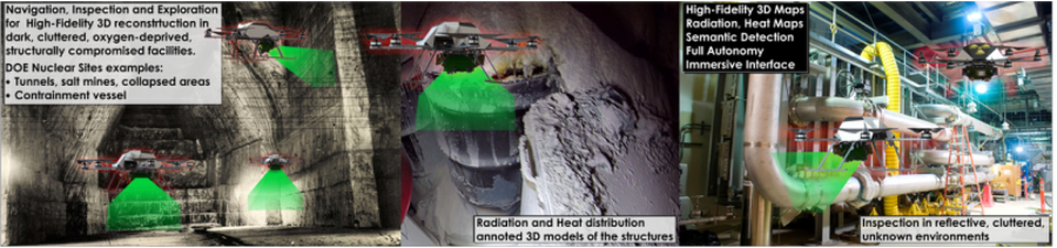
Description: A century of nuclear research, war and accidents created a worldwide legacy of contaminated sites. Massive cleanup of that nuclear complex is underway. Our broad research goal is to addresses means to explore and rad-map nuclear sites by deploying unprecedented, tightly integrated sensing, modeling and planning on small flying robots. Within this project in particular, the goal is to develop multi-modal sensing and mapping capabilities by fusing visual cues with thermal and radiation camera data alongside with inertial sensor readings. Ultimately, the aerial robot should be able to derive 3D maps of its environment that are further annotated with the spatial thermal and radiation distribution. The particular student effort refers to the investigation of efficient localization methods through the fusion of visual-inertial cues. The work will be conducted mostly at UNR and the relevant hardware components will be provided.
Collaborators: Truckee Meadows Community College
Supervisors: Kostas Alexis (UNR), Kurt Ehlers (TMCC)
Description: A century of nuclear research, war and accidents created a worldwide legacy of contaminated sites. Massive cleanup of that nuclear complex is underway. Our broad research goal is to addresses means to explore and rad-map nuclear sites by deploying unprecedented, tightly integrated sensing, modeling and planning on small flying robots. Within this project in particular, the goal is to develop multi-modal sensing and mapping capabilities by fusing visual cues with thermal and radiation camera data alongside with inertial sensor readings. Ultimately, the aerial robot should be able to derive 3D maps of its environment that are further annotated with the spatial thermal and radiation distribution. The particular student effort refers to the investigation of efficient localization methods through the fusion of visual-inertial cues. The work will be conducted mostly at UNR and the relevant hardware components will be provided.
Collaborators: Truckee Meadows Community College
Aerial Robotics for Climate Monitoring and Control
Supervisors: Kostas Alexis (UNR)
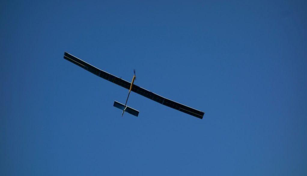
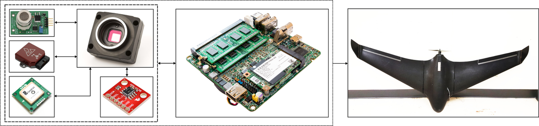
Description: Within that project you are requested to develop an aerial robot capable of environmental monitoring. In particular, an “environmental sensing pod” that integrates visible light and multispectral cameras, GPS receiver, and inertial, atmospheric quality, as well as temperature sensors. Through appropriate sensor fusion, the aerial robot should be able to estimate a consistent 3D terrain/atmospheric map of its environment according to which every spatial point is annotated with atmospheric measurements and the altitude that those took place (or ideally their spatial distribution). To enable advanced operational capacity, a fixed-wing aerial robot should be employed and GPS-based navigation should be automated. Ideally, the aerial robot should be able to also autonomously derive paths that ensure sufficient coverage of environmental sensing data.
Supervisors: Kostas Alexis (UNR)
Description: Within that project you are requested to develop an aerial robot capable of environmental monitoring. In particular, an “environmental sensing pod” that integrates visible light and multispectral cameras, GPS receiver, and inertial, atmospheric quality, as well as temperature sensors. Through appropriate sensor fusion, the aerial robot should be able to estimate a consistent 3D terrain/atmospheric map of its environment according to which every spatial point is annotated with atmospheric measurements and the altitude that those took place (or ideally their spatial distribution). To enable advanced operational capacity, a fixed-wing aerial robot should be employed and GPS-based navigation should be automated. Ideally, the aerial robot should be able to also autonomously derive paths that ensure sufficient coverage of environmental sensing data.
Robots to Study Lake Tahoe!
Supervisors: Kostas Alexis (UNR)
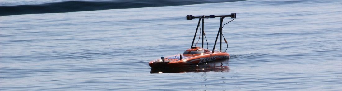
Description: Water is a nexus of global struggle, and increasing pressure on water resources is driven by large-scale perturbations such as climate change, invasive species, dam development and diversions, pathogen occurrence, nutrient deposition, pollution, toxic chemicals, and increasing and competing human demands. These problems are multidimensional and require integrative, data-driven solutions enabled by environmental data collection at various scales in space and time. Currently, most ecological research that quantifies impacts from perturbations in aquatic ecosystems is based on (i) the collection of single snapshot data in space, or (ii) multiple collections from a single part of an ecosystem over time. Ecosystems are inherently complex; therefore, having access to these relatively coarse and incomplete collections in space and time could result in less than optimal data based solutions. The goal of this project is to design and develop a platform that can be used on the surface of a lake to quantify the water quality changes in the nearshore environment (1-10 m deep). The platform would be autonomous, used to monitor the environment for water quality (temperature, turbidity, oxygen, chl a) at a given depth.
Collaborators: Aquatic Ecosystems Analysis Lab: - http://aquaticecosystemslab.org/
Supervisors: Kostas Alexis (UNR)
Description: Water is a nexus of global struggle, and increasing pressure on water resources is driven by large-scale perturbations such as climate change, invasive species, dam development and diversions, pathogen occurrence, nutrient deposition, pollution, toxic chemicals, and increasing and competing human demands. These problems are multidimensional and require integrative, data-driven solutions enabled by environmental data collection at various scales in space and time. Currently, most ecological research that quantifies impacts from perturbations in aquatic ecosystems is based on (i) the collection of single snapshot data in space, or (ii) multiple collections from a single part of an ecosystem over time. Ecosystems are inherently complex; therefore, having access to these relatively coarse and incomplete collections in space and time could result in less than optimal data based solutions. The goal of this project is to design and develop a platform that can be used on the surface of a lake to quantify the water quality changes in the nearshore environment (1-10 m deep). The platform would be autonomous, used to monitor the environment for water quality (temperature, turbidity, oxygen, chl a) at a given depth.
Collaborators: Aquatic Ecosystems Analysis Lab: - http://aquaticecosystemslab.org/
Study links• Python/MATLAB examples for aerial robotics: check each section of the Online Textbook
• Proposed literature |
Open-Source Code• RotorS Simulator: https://github.com/ethz-asl/rotors_simulator
• Structural Inspection Path Planning: https://github.com/ethz-asl/StructuralInspectionPlanner • Receding Horizon Next-Best-View Planner: https://github.com/ethz-asl/nbvplanner |
More• Check our course on Aerial Robotics
• Check this course on Unmanned Aerial Systems at ETH Zurich • Check this course on Aircraft Stability and Control from MIT • Check this great open-source project on autopilot design: https://pixhawk.org/ |